Help Find Jim Gray
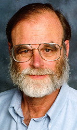
Computer science icon Jim Gray mysteriously disappeared after a solo trip with his sail boat outside San Francisco Bay. The coast guard has been searching for 4 days but has not been able to locate anything, not even debris. On Thursday 3 private planes searched through the coastal areas and they also returned unsuccessful.
Through a major effort by many people we were able to have the Digital Globe satellite make a run over the area on Thursday morning and have the data made available publicly. We have split these images into smaller tiles that can be easily scanned visually and stored into the Amazon S3 storage service. We then created tasks for reviewing these images and loaded then into the Amazon Mechanical Turk Service.
This is where you come in. We need your help in reviewing these images to see whether you can locate Jim’s boat in any of these images. Please go to the Amazon Mechanical Turk site and help us find Jim Gray.
The weather conditions were not ideal as some areas were cloudy, but we can still look for him in those places where there is a somewhat clear view. We hope to get more satellite data in the coming days of a wider area. The current images are panchromatic with a 0.82m, and Jim boat would be about 6 pixels in size. Please visit the Amazon Mechanical Turk site for more details.
I have to stress that many individuals and companies are to thank for making this possible; many academics friends relentlessly worked around the clock to get access to the data, many industry friends of Jim functioned as connectors to hook up officials and individuals, and people from NASA, Digital Globe, Microsoft, Google, Oracle, Amazon and others worked hard get to the data collected and available on a very short time scale. The Mechanical Turk team worked deep into the night to make this work.
Now it is your turn, go find Jim Gray.
Update 2/3: We have now added the data from yesterdays NASA ER-2 flight to system. They are in the same Mechanical Turk Group as the satellite images search. Please follow this link to work on these. More details here
Update 2/4: Over 100,000 assigments have been completed, and new high resolution images are coming online. More details here.
1 TrackBacks
Listed below are links to blogs that reference this entry: Help Find Jim Gray.
TrackBack URL for this entry: http://mt.vogels.net/mt-tb.cgi/68
Update Feb 3. Help find Jim. He is not only one of the smartest guys I ever met, he's also one of the nicest. I was lucky enough to be working at Digital in the late 80s when we started hiring the big brains in transaction processing -- including Jim -... Read More

Werner,
I am sure that you guys have thought about this. With clouds and all kinds of point-like singularities, it is difficult to figure out automatically longer "things" in images. A way to go around this and find more automatically where those elongated objects could be would be to use either curvelets:
http://www.curvelet.org/
or
contourlets:
http://www.ifp.uiuc.edu/%7Eminhdo/software/
The ability to find elongated features in images of S/N = 0.1 seems feasible from some of the papers I saw (take a look at the examples in the ref section below). I don't really have access to a computer where I can do that computations on the set of images you have on Mechanical Turk, but I would imagine somebody has already done this.
On a totally unrelated note, we flew a $500 camera on a helium balloon in september and were able to get satellite imagery capability while flying at 36 km up:
http://hasp-geocam.blogspot.com/2006/10/comparing-satellite-imagery-and-geocam.html
http://sei.tamu.edu/geocam/
http://sei.tamu.edu/geocam/Panoramas/panorama_22-23-50pct.htm
on a smaller balloon than the one we used, you could fly for about two hours and cover the same area you have been getting from digital globe.
Finally, while the mechanical turk database is fine, it seems to me that the eye is very capable of exploring lots of data if one can get access to the whole imagery. For people to get access to our gigapixel panoramas we used Zoomify.
http://sei.tamu.edu/geocam/Panoramas/panorama_22-23-50pct.htm
Good luck,
Igor.
ref: http://www-stat.stanford.edu/%7Ejstarck/rect.html
http://www-stat.stanford.edu/%7Ejstarck/line.html
Werner,
One more thing, if the panchromatic images are not giving anything, you might consider ordering EO-1 data
http://eo1.usgs.gov/
the swath is pretty small, yet it is hyperspectral/multispectral depending on the instrument used.
If there is an oil slick, you might see this as the reflection will look totally different from the rest of the sea. The same goes for the boat. Hyperion should find it (http://eo1.usgs.gov/hyperion.php)
Good luck again,
Igor.
Werner,
Another thing, if you look at the hyperion capabilities, http://www.eoc.csiro.au/hswww/oz_pi/SCITEA3.PDF
you'll find that the GSD is 29 m i.e larger than the boat. Yet with 250 bands (as opposed to the usual 3), one can do subpixel analysis or at least have the knowledge that some investigation is required in that location. As opposed to ground investigation, an investigation with the sea as a background should help in seeing foreign objects better.
Igor.
Hey There,
Those satellite images are pretty noisy, meaning it's pretty difficult to discern much of anything. It's difficult to find what's different in the noise, but I think it would be much easier to find where the motion in a time series of images of the same location is different. (ie: present three images taken of the same location with a 1s delay in between) Hard and straight lines would remain so througout the series where noise and reflection would vary.
I don't know if that's technically feasible, but if you could make it happen relatively easily, it would make it easier to spot anomalous images greatly increase chances of success for this effort.
Good luck!
--adam
Hello all,
why do you not insert aerial photos of Pacific Ocean in Google Earth, so we can search near Hawaii route ?
Regards
BobMaX